Hiking Trails Award
Oak Mountain Recreational Demonstration Area – Camp 1B
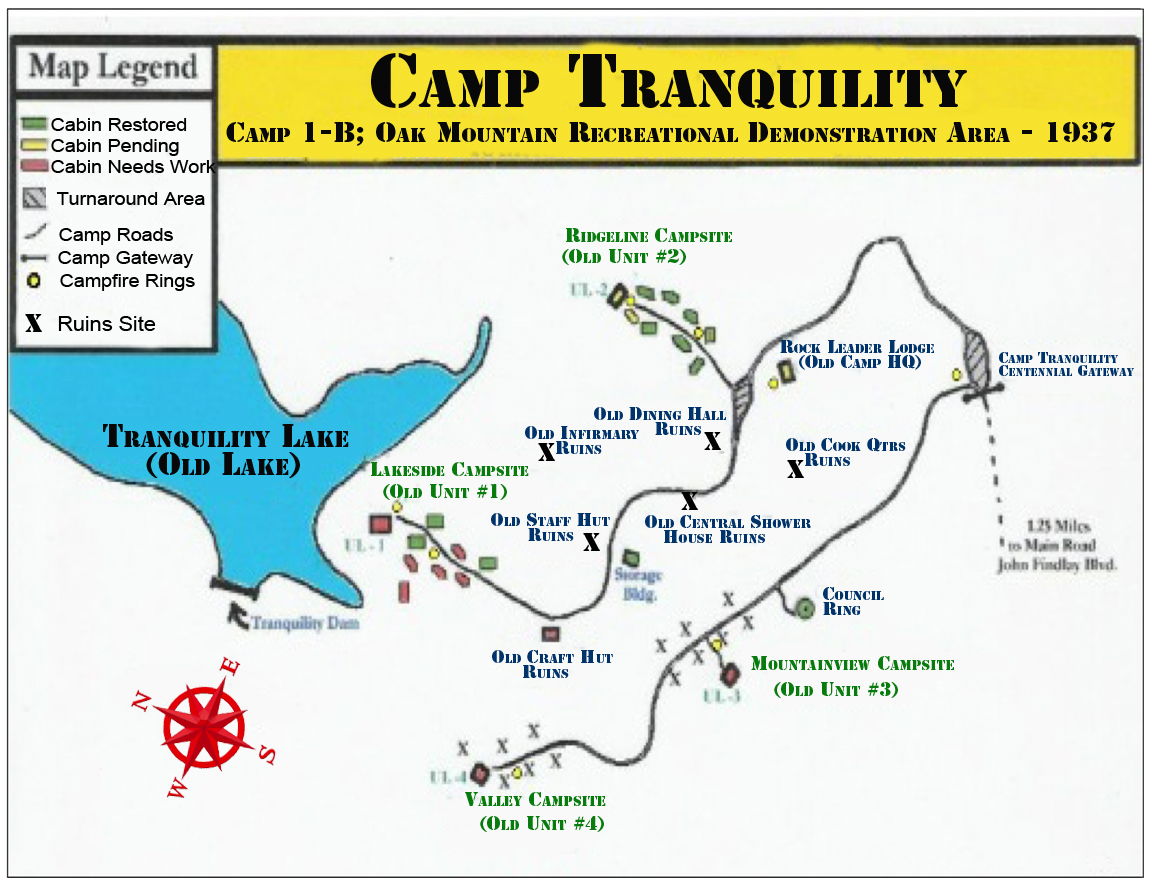
Camp Tranquility was established in 1937 by the U.S. Department of the Interior via work completed by the Civilian Conservation Corp (CCC) & Works Progress Administration (WPA). The camp was originally designated as the Oak Mountain Recreational Demonstration Area (RDA) – Camp 1B. It was given the name Camp Tranquility based on the tranquil nature of the area and its proximity to the OMSP Tranquility Camping Area. RDA’s were built all across the United States and Camp Tranquility represents the last unit that stands in its original state. Its purpose was to serve as an outdoor opportunity for the youth of the surrounding areas. For the first few years of its existence, the Camp served mainly as a Summer Camp for the Boy Scouts of America. Other organizations also used the Camp for many years to follow. The Camp was composed of Four Units, now known by names (1 – Lakeside; 2 – Ridgeline; 3- Mountainview; 4 – Valley). Each Unit had a large Unit Lodge & roughly 7- 8 Sleeping Cabins. They had electricity and the Latrines had running water. There was a Central Dining Hall; Camp Infirmary; Central Shower House; Staff Cabins; Leader Lodge; Council Ring; and a Waterfront. Today all that remains of the Camp are the Sleeping Cabins in Lakeside & Ridgeline; Ridgeline Unit Lodge; Ridgeline Latrine; Rock Leader Lodge; & a Cinderblock Storage Building. The Ridgeline Unit is the last complete RDA Unit left in the U.S
Eagle Scout Projects – In 2007, the Camp was brought back to life through a Memorandum of Understanding with the Camp Tranquility Preservation Association and the Alabama Department of Conservation & Natural Resources (DCNR). At that time, Eagle Scout Projects began to help restore and renovate the Sleeping Cabins & Lodges around Camp Tranquility. To date, over 45 Eagle Scout Projects have been completed. These projects have helped provide Historical Markers for Camp; Gateways; Signage; Kiosks; Roadwork; Fire Rings; Benches; Flagpoles; and Walls. Other Eagle Projects have worked toward completing Cabins in Ridgeline & Lakeside; Unit Lodge in Ridgeline; Rock Leader Lodge; Ridgeline Latrine; & Council Ring. There are many more Projects available and we hope the Camp Tranquility Trail Award Program will be an impetus for Scouts & Troops to complete future projects. The artisans of the CCC & WPA who created these works should not have their labor simply evaporate with the passage of time. We do not want to look back at the ghostly chimneys of the site and ask what it might be like today if we had taken the time to save her.
1) Brock Peacock – T404 (Maple) Cabin Unit 2 – complete
2) Blake Dillard – T404 (Sweet Gum) Cabin Unit 2 – complete
3) Josh Lowe – C532 Council Ring – complete
4) Blake Dobbins – T404 Roofs (Maple & Sweet Gum) Cabins Unit 2 – complete
5) William T. Fine – T828 Unit 1 Cabin – complete
6) Bradley Connor Pinkerton – T828 Unit 1 Cabin – complete
7) Jalen Simpson – T246 Unit 1 Cabin –complete
8) Robert Byrne – T320 Unit 2 Lower Cabin – 3rd on Left (Poplar) – complete
9) David Frolander – T2 Unit 1 Roofs on Fine & Pinkerton Cabins – complete
10) Matt Stewart T540 – Unit 2 Cedar Cabin – complete
11) Frederick DeLeon – T7 Unit 2 (Dogwood) Cabin – 4th on Right – complete
12) Ewan Handgraft – T71 Unit 2 (Pine) Cabin – 3rd on Right – complete
13) Kyle Edsall – T532 Camp Tranquility Signage – complete
14) Michael Barrett – T396/T2 – Camp Gateway / Sign – complete
15) Alex Atwood – T5 Unit 1 Cabin – complete
16) Brandon Allie – T28 Flagpole Lakeside campsite – complete
17) Stephen Mixson – T2 Camp Flag Pole Rock Leader Lodge – complete
18) Henry Kendrick – T119 Latrine – 1st on right – complete
19) Jake Bowers – T2 Cameron Cabin / Lodge exterior – complete
20) Zac Turner – T2 Camp Tranquility Kiosk – complete
21) Alec Lee – T2 Camp Tranquility DOI/NPS Entrance Sign – complete
22) Robby Brantley – T2 Camp Tranquility Pavilion Flat
23) Jared Gordon – T367 Camp Tranquility Fire Rings – complete
24) Jacob Gordon – T367 Camp Tranquility Unit Lodge Exterior – complete
25) Davis Faulkner –T2 Hornaday Project – Camp Road – complete
26) William Earnest – T96 Rock Leader Lodge Interior & Porch – complete
27) Harrison Winter – TXX Lakeside Cabin 2nd on left – complete
28) Chase Byers – T540 Cinderblock Building New Roof – complete
29) Jacob Holland – T83 Cinderblock Building – Painted & New Metal Door – complete
30) Nathan Lovvorn – Contractor (Eagle Scout) – New Roof Unit Lodge Ridgeline via AHC Grant
31) John Freeman – T320 Camp Tranquility Cabin Roof Flashing & Railing – complete
32) Hunter Whitehurst – T83 Main Gateway #1 – complete 9/2015
33) Andrew Foxhall –T532 Council Ring Refurbishment – complete 3/2017
34) Arlington Pittman – T538 Cabin Siding restoration Ridgeline – complete 3/2017
35) Brandon Lee – T2 CT Historical Marker – complete 6/2016
36) Evan Caufield – T23 Gateway #2 & #3 – complete 4/2018
37) Wesley Lamberton – T538 Flagpole Ridgeline Unit Lodge – complete 11/2019
38) John Evans – T119 Fieldstone Wall CT Historical Marker – complete 11/2020
39) Peter Pittman – T538 Flagpole Ring Ridgeline Unit Lodge 5/2021
Trail Hiker Award Program – In 2021, Camp Tranquility introduced the Trail Hiker Award Program. Scouts who participate in this Program can earn a special hiking medal & patch while camping and completing Service Projects. The guides for earning the Awards are listed below:
- Scouts must hike the Red (5.5 miles), Blue (6.7 miles) & Yellow (8 miles) Trails at Oak Mountain State Park. This is a total of 20.2 miles overall
- Camp two nights at Camp Tranquility, getting prior approval from CTPA
- Complete a four hour Service Project at Camp Tranquility based on a list supplied by CTPA and approved ahead of time
- When the above actions have been completed, the Unit Leader will advise the CTPA Hiking Committee that the listed Scouts & Leaders have earned the Camp Tranquility OMSP Hiker Medal
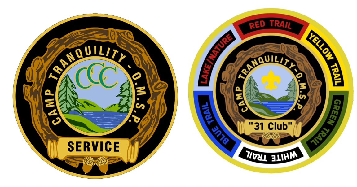
- Scouts must hike the Red (5.5 miles), Blue (6.7 miles) & Yellow (8 miles) Trails at Oak Mountain State Park. This is a total of 20.2 miles overall. In addition, they must complete the White (6.4 miles), Lake/Nature (2.4 miles); & Green (2 miles) for a grand total of 31 miles
- Camp an additional two nights (total of four) at Camp Tranquility, getting prior approval from CTPA.
- Complete an eight hour (total of 12 hours) Service Project at Camp Tranquility based on a list supplied by CTPA and approved ahead of time
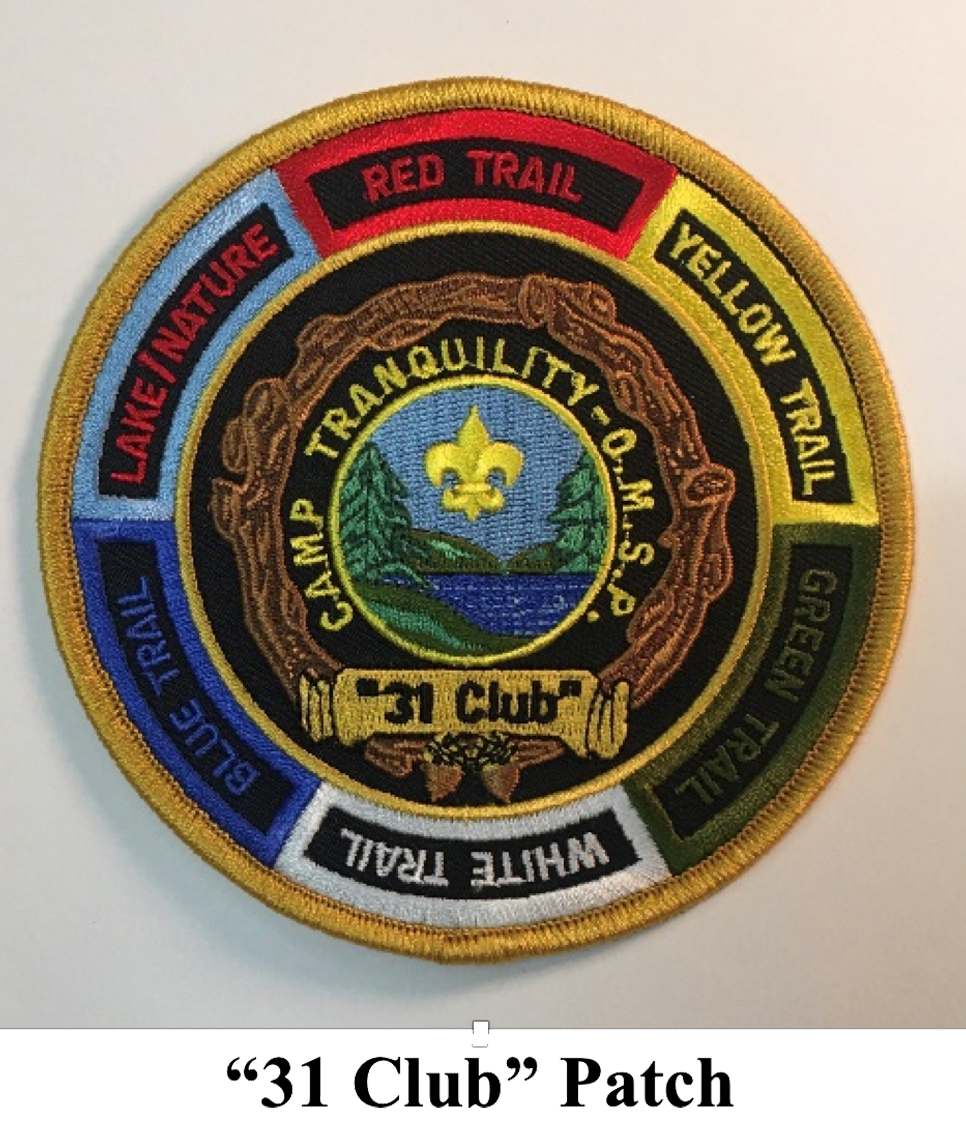
- When the above actions have been completed, the Unit Leader will advise the CTPA Hiking Committee that the listed Scouts & Leaders have previously earned the Camp Tranquility OMSP Hiker Medal & are now entitled to the “31 Club” embroidered patch and “31 Acorn Pin Device” for their previously earned Trail Medal. **Note: One Trail Medal per life – No additional purchases.

Awards – The Trail Awards consist of a 1.75 inch pewter cast Trail Medal suspended from a Red, Blue & Yellow ribbon. The colors represent the first three Trails that must be hiked to complete the initial 20 miles. The Medal highlights the Camp Tranquility logo with the “Hiker” designation. Surrounding the logo are the Trails that are located at OMSP. A “31 Club” Oak Acorn Pin is available to augment the Trail Medal & a “31 Club” Patch that is 4.5 inches fully embroidered and are also awarded only for completing the additional requirements beyond the 20 Mile Medal as set forth by the CTPA Hiking Committee.
Camp Tranquility Map
Unit 1 – Lakeside (4 Cabins)
Unit 2 – Ridgeline (7 Cabins; 1 Latrine; 1 Unit Lodge)
Unit 3 – Mountainview (primitive site – tent camping only)
Unit 4 – Valley (primitive site – tent camping only)
Red Trail/Road, White, Blue, North Lakes Connector Trail, and Yellow Trails all begin at the North Trailhead, which is located on John Findley Drive about 6 miles inside the park if you are coming from the Front Gate. If you use the back entrance, it is about 1.5 – 2 miles inside the gate.
Treetop Nature Trail begins at the beach access parking lot.
Green Trail begins near the Park Office on Terrace Drive.
Yellow Trail also ends on Terrace Drive near the South Trailhead.
Lake Trail has entrances on Terrace Drive.
OMSP has implemented a trail marking system on all of the hiking trails. This does not, at the present time, include the Orange Trail, or the Treetop Nature Trail. This marking system is designed to help us cut down on the search time and area when someone is hurt or lost. Each trail is uniquely colored and numbered. The posts are placed approximately every 1/4 mile and colored the same as the trail. Each post has a number and they do NOT repeat. A lost or injured hiker can call us and tell us the number of the last post that they passed & we can tell them the best way to get out or we can go almost straight to them in a short amount of time. The number to call is 205-620-2520.
Blue Trail 1 to 26
White Trail 27 to 51
Green Trail 52 to 59
Yellow Trail 60 to 86
Red Road 100 to 121
Call 205-620-2520 for Park Rangers or 911 in case of emergency
TRAILS OF OMSP:
The Red Road/Trail is a 5.5 mile trail and original logging road for the CCC to build the park in the 1930s. You must turn around and come back the way you came or pick up a connector trail to go a different way. It begins at the North Trailhead and follows a path similar to the Blue Trail but at a lower elevation and is an easier hike for most.
The White Trail, or the Shackleford Point Trail, is 6.4 miles long (one way). You must turn around and come back the way you came or pick up a connector trail to go a different way. It begins at the North Trailhead and follows a path similar to the Blue Trail but at a lower elevation. The White Trail does climb to the highest point in the park, which is known as Shackleford Point at an elevation of 1,260 feet. The White Trail ends at the Peavine Falls parking lot.
The Blue Trail, or the South Rim Trail, is 6.7 miles long (one way). You must turn around and come back the way you came or pick up a connector trail to go a different way. Beginning at the North Trailhead, the Blue Trail makes a steep climb up the ridge, going from an elevation of approximately 620 feet to approximately 1100 feet. Once the ascent is made, the trail follows the ridge to end at the Peavine Falls parking lot.
The Yellow Trail, known as the Foothills Trail, is approximately 8 miles long (one way). It begins at the North Trailhead and travels at a low elevation around Lake Tranquility to end at Peavine Road close to the South Trailhead area (off Terrace Drive). The Yellow Trail does make some climbs.
Maggie’s Glen is a popular spot to hike to. It sits along a stream bank with many species of plants and trees growing there. It is a very quiet place to sit and relax. It can be accessed from the White Trail, the Yellow Trail, and the Red/Yellow connector.
The Green Trail, known as the Peavine Falls Trail, begins near the Park Office/Beach area on Terrace Drive. It is the shortest trail at 1.9 miles long, but it is also the steepest. The Green Trail goes from an elevation of approximately 550 feet to approximately 1,100 feet. The Green Trail doesn’t lead directly to Peavine Falls (the waterfall) but ends at the Peavine Falls parking lot where you can get on the White or Blue Trail that will take you to the falls. About 1 mile up the trail from Terrace Drive, you begin a climb from approximately 800 feet to approximately 1,020 feet.
The Lake Trail is a multi-use hike and bike trail around Double Oak Lake located on Terrace Drive. There are 2 main entrances to the Lake Trail – you can park at the Marina and walk back to an entrance or you may park at the South Trailhead Parking lot and pick up the trail there. The Lake Trail is 2.3 miles long and can connect you to a section called Rattlesnake Ridge. It is popular with bikers because of the numerous switchbacks. You can observe scenic views of Double Oak Lake as you walk or bike around this trail. It has a gentle rolling terrain with some incline in certain areas.
The Treetop Nature Trail is a short 0.3 mile trail. It leads from the beach parking lot up to the Wildlife Center. It also connects to the Treetop Nature Trail (which is an elevated boardwalk with several cages housing birds of prey that have been rehabilitated after having been injured), the Yellow Trail, and the Orange Trail.
There are several connector trails so that you may make loops so that you don’t have to walk the whole length of trail if you don’t want or to give you a different route on the way back.
Trail Maps can be downloaded here: https://www.alapark.com/sites/default/files/2019-07/OMSPparkmap_0.pdf
In the event you are injured or lost try to remember the acronym T.R.A.I.L.S.
Try to Stay Calm – It may take some time for someone to know you are missing, but once they do, we will be notified and looking for you.
Remain Where You Are – Doubling back or even pressing forward can lead you further away from where you initially got lost. So, it is important to stay where you are. This way we can find you faster.
Alert Somebody – Cell phone signals may be spotty. If you can, try texting someone, calling the park office or 911. Let them know the last intersection you passed. If you do not have the battery life or enough cell signal to text or call, use a whistle if you have one.
Insulate Yourself – Wear the light jacket to keep yourself warm and protected from insects at night or use it to shield yourself from the sun during the day.
Listen for People Calling for You – Once alerted to the situation, our search and rescue team will be looking and calling for you, so remember to listen. If you hear us, try to use your whistle, or flashlight at night, to alert us where you are located.
Save Your Supplies – Try to ration your water and snacks since it may be a little while before we find you.
Contact Information for the Service Projects; Use of Camp Tranquility & Trail Awards – Email: campmoreland@gmail.com
**Note: Include your Unit Number; Number of Attendees & Dates requested in the email.
Cost to stay at Camp Tranquility is $5 per person with checks payable to CTPA. Payment must be received before the requested dates so that Gate Codes can be released to Unit Leadership. In addition, once approval is secured from CTPA, the Unit will need to contact OMSP Camping to advise this have been approved so they can monitor campers in the Park.
Once Camp requirements, Trail Hikes & Service Projects have been completed at Camp Tranquility, Leaders will need to finalize the attached Trail / Service Project Credential Form and mail to the address noted along with a check for the requested Awards.
Award Pricing:
Medals: $10 each (only for those completing the initial 20 miles, camped/service project – one per person)
“31 Club” Pin: $5 each (only for those earning the Medal previously & who have hiked the addition 11 miles/camped/service project)
“31 Club” Patch: $5 each (same as requirements for “31 Pin”)
Shipping & Handling: $10
Credential Sheet & Check (payable to CTPA) mailed to:
CTPA
311 Kilkerran Lane
Pelham, AL 35124